IRVEN brings together energy, infrastructure, climate and territorial information to help you choose locations, prioritize investment and assess energy savings opportunities.
Initial focus: Hermosillo, SonoraFor industry and public institutions
FROM TERRITORY TO DECISION↗
One area. Its full context.
InfrastructureEnergyTerritory
What should you review first?
Comparable locations, visible constraints and a clear next step.
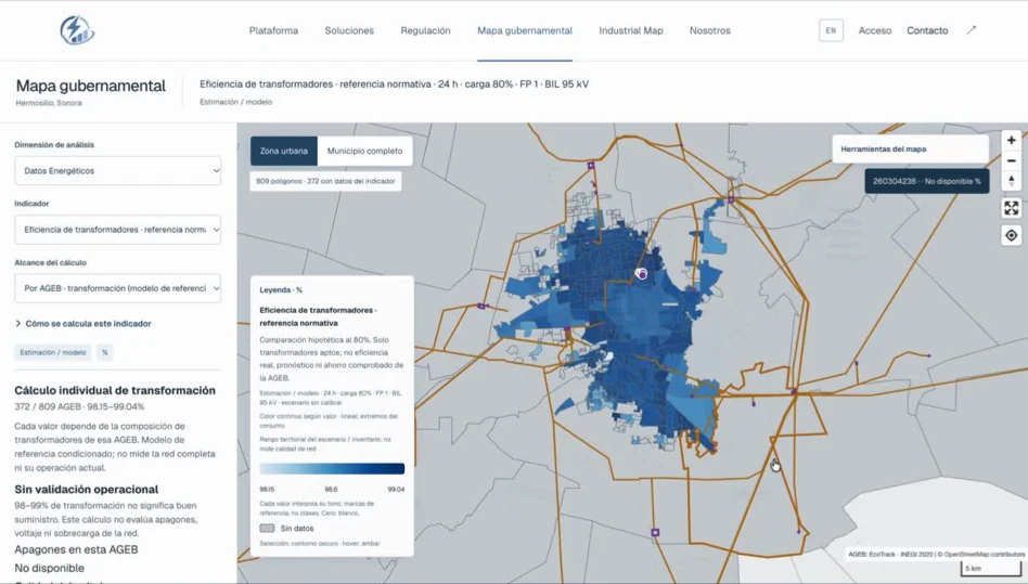
Platform screenshot presented at FireCAMP 2026. See each map for sources and dates.
INFORMATION IN CONTEXT
INEGI · OpenStreetMap · energy and climate sources
THE PROBLEM
Information is scattered. Investment cannot wait.
Choosing land or planning infrastructure expansion means combining information scattered across maps, documents and spreadsheets. IRVEN puts it in context so your technical team can focus on the alternatives worth studying.
01 / WHO IT IS FOR
Two needs. A better basis for decisions.
For teams that need to justify where to invest and what to verify before committing resources.
INDUSTRY01 ↗
Plan your next facility.
Manufacturers, warehouses and industrial parks planning to locate or expand energy-intensive operations.
Engineering · Operations · Finance · Expansion
Compare land and its electrical context.
Review area, zoning and restrictions.
Prepare demand and cost scenarios using project inputs.
↳
A shortlist of locations and the checks still needed.
Compare alternatives using space requirements, nearby infrastructure and available territorial constraints.
Decision: which sites merit a field visit.02
Which area should come first?
Compare energy and territorial indicators while distinguishing estimates from measurements.
Decision: where to focus studies and resources.03
Which improvement should we assess?
Compare consumption, loss and transformer reference scenarios with explicit inputs and assumptions.
Decision: which option merits measurement and a quotation.
↳Proximity to a line or substation does not confirm available supply capacity. Electrical feasibility, the connection point and permits require verification by CFE and the relevant authorities.
03 / HOW IT WORKS
Integrate. Analyze. Decide what comes next.
From your project question to a comparison you can explain and inspect.
01→
Integrate the context
Location, infrastructure, energy, climate and population, alongside your project requirements.
Identified data and sources
02→
Analyze alternatives
Combine variables, surface constraints and compare scenarios using the same criteria.
Comparable options
03✓
Guide the next step
Organize priorities, results and missing information to establish what to verify before investing.
An evidence-backed shortlist
04 / RELIABILITY AND PRIVACY
Trust starts with knowing where each result comes from.
↗
Sources, dates and coverage
Maps identify sources, dates and data availability. Freshness depends on each source; not all data updates in real time.
≈
Clearly marked estimates
Observations, calculations and models are distinguished. Assumptions and gaps are part of the assessment; missing data does not become zero.
◎
A clear scope for your data
Map project files can be saved or exported from your browser. Initial contact prepares an email without automatically attaching documents or publishing your information.
INFORMED BY PLANNING TEAMS
Interviews with CFE planning personnel informed the focus: comparing alternatives, spotting constraints and checking source freshness. Local accuracy requires comparison with real projects and measurements.